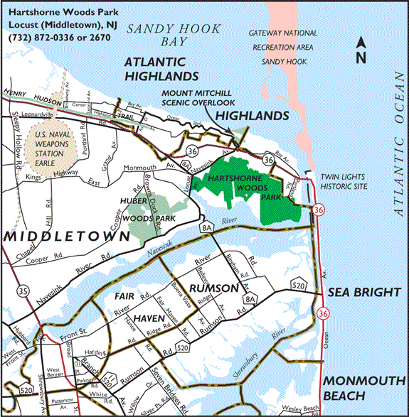
After I rode the Fox Hollow trail at Huber Woods Park, I was feeling fine and I had a couple of hours before I had to return home. I decided to check out the trails at Hartshorne Woods Park. I loaded my bike into my car and drove over to Hartshorne Woods, a short distance from Huber Woods, and parked at the Buttermilk Valley Entrance parking lot. There is another entrance further west called Rocket Point Entrance.
I ended up riding the Laurel Ridge trail to the Grand Tour trail to the Cabin overlooking the maintenance area and doubling back to the parking lot.
The mostly single-track trails that I was on seem to be well maintained with a mix of packed dirt, gravel and sand. Unlike Huber Woods, the sand is used sparingly and is packed down with the dirt and gravel. Small to medium sized rocks, roots and tree branches made the trails very bumpy and challenging. On the short stretch of trails that I was on, there were no flat sections. I was either climbing a steep hill or descending a steep hill.
Where the trails wound through the woods, fallen leaves cover most of the trail floor and cover up some of the rocks and roots sticking out of the ground. The fallen leaves create hidden dangers and extra care is required when you want to fly down the hills. Also, keep in mind that all trails rated moderate and challenging in Hartshorne Woods are multi-use trails so you need to check your speed going down those hills.
If the trails that I was on are a sample of what the rest of the trails in Hartshorne Woods Park are like, I don’t think I will be bringing my two sons to ride any of the trails any time soon.
Map of Hartshorne Woods Park
Summary:
Hilly and difficult single-track multi-use trails not recommended for the beginning mountain bike rider. The trails are definitely not for young children or kids.
Trail Description:
Well maintained. Hard packed. Laurel Ridge trail is rated as moderate. Grand Tour trail is rated as challenging.
Directions:
To Buttermilk Valley Entrance Parking Lot:
From State Highway 35 northbound: just north of the Cooper Bride turn right onto Navesink River Rd. Travel about 4.7 miles and turn right onto Locust Road. Cross Clay Pit Creek Bridge to a five-way intersection. Bear right onto Navesink Avenue and continue to Buttermilk Valley Entrance parking area on the right.
From State Highway 35 southbound: just before the Cooper Bridge into Red Bank, use jug handle to make left turn onto Navesink River Rd. Travel about 4.7 miles and turn right onto Locust Road. Cross Clay Pit Creek Bridge to a five-way intersection. Bear right onto Navesink Avenue and continue to Buttermilk Valley Entrance parking area on the right.
Showing posts with label bike ride review. Show all posts
Showing posts with label bike ride review. Show all posts
12.05.2008


Huber Woods Park
I was at Huber Woods Park Middletown Environmental Center Navesink River Road Locust Point Road
The trail was mostly single-track and hilly with the usual rocks and roots. There were a few small logs across the trail but nothing that a novice like me can’t jump over. The hills were manageable but the trail was deep and narrow at some spots from erosion. Some spots were so deep and narrow that there was only couple of inches of clearance on either side for the pedals.
There were also a lot of sand patches that will definitely slow my ride. Fox Hollow is a multi-use trail so watch out for runners, hikers and children on the trail. There were also horse droppings here and there.
I will try some of the other trails in
All-in-all the Fox Hollow trail was easy to ride for a novice. But the trail may be a bit tough for my two sons because of the deep and narrow single-track and sand patches.
Summary:
Easy and enjoyable enough single-track multi-use trail for the novice mountain bike rider. The trail is hilly and eroded and narrow at some spots so younger kids may find it difficult and may walk some of the trail. If you want to hike the trail I think you will find the walk difficult because of the depth and narrowness of the trail.
Trail Description:
A one mile multi-use loop trail rated as Easy. Hilly with deep and narrow single-track at some spots. Lots of sand patches.
Directions:
From State Highway 35 northbound: just north of the Cooper Bride turn right onto Navesink River Rd. Travel about 2.8 miles and turn left onto unpaved Browns Dock Road. Go pass the
From State Highway 35 southbound: just before the Cooper Bridge into Red Bank, use jug handle to make left turn onto Navesink River Rd. Travel about 2.8 miles and turn left onto unpaved Browns Dock Road. Go pass the
11.02.2008
Easy Ride at Manasquan Reservoir
It was a beautiful day for a trail, non-technical ride around the Manasquan Reservoir in Howell Township, Monmouth County. My sons and I did the Perimeter Trail which is a multi use (hiking, horseback riding, biking) five miles loop around the reservoir. The trail is generally very wide except for the wooden bridges and a few spots in the woods. The terrain is flat with packed gravel. There are a few inclines and twist and turns to make the trail fun to ride.


It took us about half an hour to complete the loop at a steady pace with a few stops for pictures. But plan on one to two hours if you will be riding with young children or if you plan to stop along the way to enjoy some the views.
Besides hiking, horseback riding and biking, there are also canoe, kayak and rowboat rentals, boat tours, fishing, picnic tables and barbeque pits, and children's playground. There is also an Environmental Center with exhibits and observation posts of nesting ospreys.


The Manasquan Reservoir is a great place for an easy trail ride or hike with kids and youngchildren.
Summary:
Easy hike and bike ride around a five mile loop around the Reservoir. Easy enough for young children and should provide a very enjoyable day out for the whole family. Besides the trail, there is also fishing. Boating, and picnicking at the Reservoir. There is also an Environmental Center.
· Garden State Parkway to Exit 98, Interstate 195 west. Proceed on I-195 west to Exit 28B, Rt. 9 north-Freehold. Stay in right lane when entering Rt. 9 north. At first traffic light, turn right onto Georgia Tavern Road. Follow Georgia Tavern Road for 0.3 mile. Turn right onto Windeler Rd. Continue 1.5 miles to the Reservoir Area on left.
· State Hwy. 9 south from Freehold to Georgia Tavern Rd. Use Jug handle to turn left onto Georgia Tavern Rd. Proceed on Georgia Tavern Rd. for 0.3 mile. Turn right onto Windeler Rd. Continue 1.5 miles to the Reservoir Area on left.


It took us about half an hour to complete the loop at a steady pace with a few stops for pictures. But plan on one to two hours if you will be riding with young children or if you plan to stop along the way to enjoy some the views.
Besides hiking, horseback riding and biking, there are also canoe, kayak and rowboat rentals, boat tours, fishing, picnic tables and barbeque pits, and children's playground. There is also an Environmental Center with exhibits and observation posts of nesting ospreys.


The Manasquan Reservoir is a great place for an easy trail ride or hike with kids and young
Summary:
Easy hike and bike ride around a five mile loop around the Reservoir. Easy enough for young children and should provide a very enjoyable day out for the whole family. Besides the trail, there is also fishing. Boating, and picnicking at the Reservoir. There is also an Environmental Center.
Trail Description:
An easy, five mile, wide loop trail around Manasquan Reservoir that winds through woods and open areas around the Reservoir. Generally flat, hard packed gravel.
An easy, five mile, wide loop trail around Manasquan Reservoir that winds through woods and open areas around the Reservoir. Generally flat, hard packed gravel.
Directions:
· Garden State Parkway to Exit 98, Interstate 195 west. Proceed on I-195 west to Exit 28B, Rt. 9 north-Freehold. Stay in right lane when entering Rt. 9 north. At first traffic light, turn right onto Georgia Tavern Road. Follow Georgia Tavern Road for 0.3 mile. Turn right onto Windeler Rd. Continue 1.5 miles to the Reservoir Area on left.
· State Hwy. 9 south from Freehold to Georgia Tavern Rd. Use Jug handle to turn left onto Georgia Tavern Rd. Proceed on Georgia Tavern Rd. for 0.3 mile. Turn right onto Windeler Rd. Continue 1.5 miles to the Reservoir Area on left.
10.16.2008
Bike Ride at Lake Minnewaska State Park
My brother and I went mountain biking this past Saturday at Lake Minnewaska State Park in the Shawngunks. My two sons didn’t want to get up for the 7:30 AM start so they stayed home for this one. They would have loved the ride. My brother and I certainly did. It was definitely worth the drive.
We pulled into the parking lot at around 10:15 AM. The lot was already half full. By the time we finished our ride and got back to the car around 1:30 PM, the lot was full and the park entrance was closed. Cars were lined up waiting to get into the park. I can’t blame people for going there that day. It was a beautiful autumn day with the temperature in the mid seventies. The foliage was just fantastic.

 Long sections of the trails are all wide old carriage road with loose gravel or dirt, exposed roots, rocks and out crops along the ledges. The trail around Lake Awosting is not a former carriage road and is narrow with lots of exposed roots and rocks.
I would rate the route that my brother and I took as moderate for the distance and grades. And it is a better ride and “easier” ride following our route instead of riding the revised direction.
We pulled into the parking lot at around 10:15 AM. The lot was already half full. By the time we finished our ride and got back to the car around 1:30 PM, the lot was full and the park entrance was closed. Cars were lined up waiting to get into the park. I can’t blame people for going there that day. It was a beautiful autumn day with the temperature in the mid seventies. The foliage was just fantastic.

We took the Upper Awosting Carriageway (Green marker) from Lake Minnewaska to Lake Awosting , around the lake on the Lake Awosting Carriageway (Black marker), and back to Lake Minnewaska by way of the Castle Point Carriageway (Blue marker). The round trip is about 12 miles and took me and my brother about three hours to complete – with plenty of stops along the way to take in the views. The first half of the route was a steady up hill with a few drips and was a lot of work. The second half of the route – the fun half – was down hill almost all the way. There was a short climb toward the end that I didn’t expect. The downhill can be fast, especially when there are no hikers on the trail to get in the way, and are dangerous, so use caution and check your speed. See more of the pictures I took at Lake Minnewaska State Park at Flickr.
 Long sections of the trails are all wide old carriage road with loose gravel or dirt, exposed roots, rocks and out crops along the ledges. The trail around Lake Awosting is not a former carriage road and is narrow with lots of exposed roots and rocks.
These trails are designated as multi-use, so expect families with young kids and strollers, hikers and horse riders.
I would rate the route that my brother and I took as moderate for the distance and grades. And it is a better ride and “easier” ride following our route instead of riding the revised direction.
I think my 11 year old and 8 year old would have handled the trail just fine even with the distance and climbs. It would be tougher for them and for me if the ride was in summer with higher temperatures and humidity.
I would not hike this route with kids. It is too long and not that interesting the first leg of the route from Lake Minnewaska to Lake Awosting.
Summary:
A scenic and intense ride – due to being close to the ledges during the descends - with mostly wide rolling trails. The trails do get crowded, especial close to Lake Minnewaska and the parking lots, so get there early in the morning.
Trail Description:
Lake Minnewaska State Park, Ulster County, New York. Shawangunk Mountain ridge more than 2,000 feet above sea level.
Upper Awosting Carriageway (Green) from Lake Minnewaska to Lake Awosting , around the lake on the Lake Awosting Carriageway (Black), and back to Lake Minnewaska by way of the Castle Point Carriageway (Blue). Twelve miles round trip: first half mostly steady up hill climbs; second half mostly down hill descend with loose rock and gravel and drops. Use caution and check your speed during descend. Yield to riders on horseback and hikers. Helmet required.
How I got there:
A scenic and intense ride – due to being close to the ledges during the descends - with mostly wide rolling trails. The trails do get crowded, especial close to Lake Minnewaska and the parking lots, so get there early in the morning.
Trail Description:
Lake Minnewaska State Park, Ulster County, New York. Shawangunk Mountain ridge more than 2,000 feet above sea level.
Upper Awosting Carriageway (Green) from Lake Minnewaska to Lake Awosting , around the lake on the Lake Awosting Carriageway (Black), and back to Lake Minnewaska by way of the Castle Point Carriageway (Blue). Twelve miles round trip: first half mostly steady up hill climbs; second half mostly down hill descend with loose rock and gravel and drops. Use caution and check your speed during descend. Yield to riders on horseback and hikers. Helmet required.
How I got there:
From the south, we took exit 18 off the New York Thruway (I-87) and turn left onto Route 299 west. Went through town and continue until Route 299 ended. Made a right onto NY Route 44/55 west. Drove drive up the hill with the hair pin turn (a landmark?), passed the rock climbing area for another three miles(?), and turned left to enter the park. Paid $6.00 at the gate and got a trail map. Drove a short distant up to the parking lot and parked.
Subscribe to:
Posts (Atom)